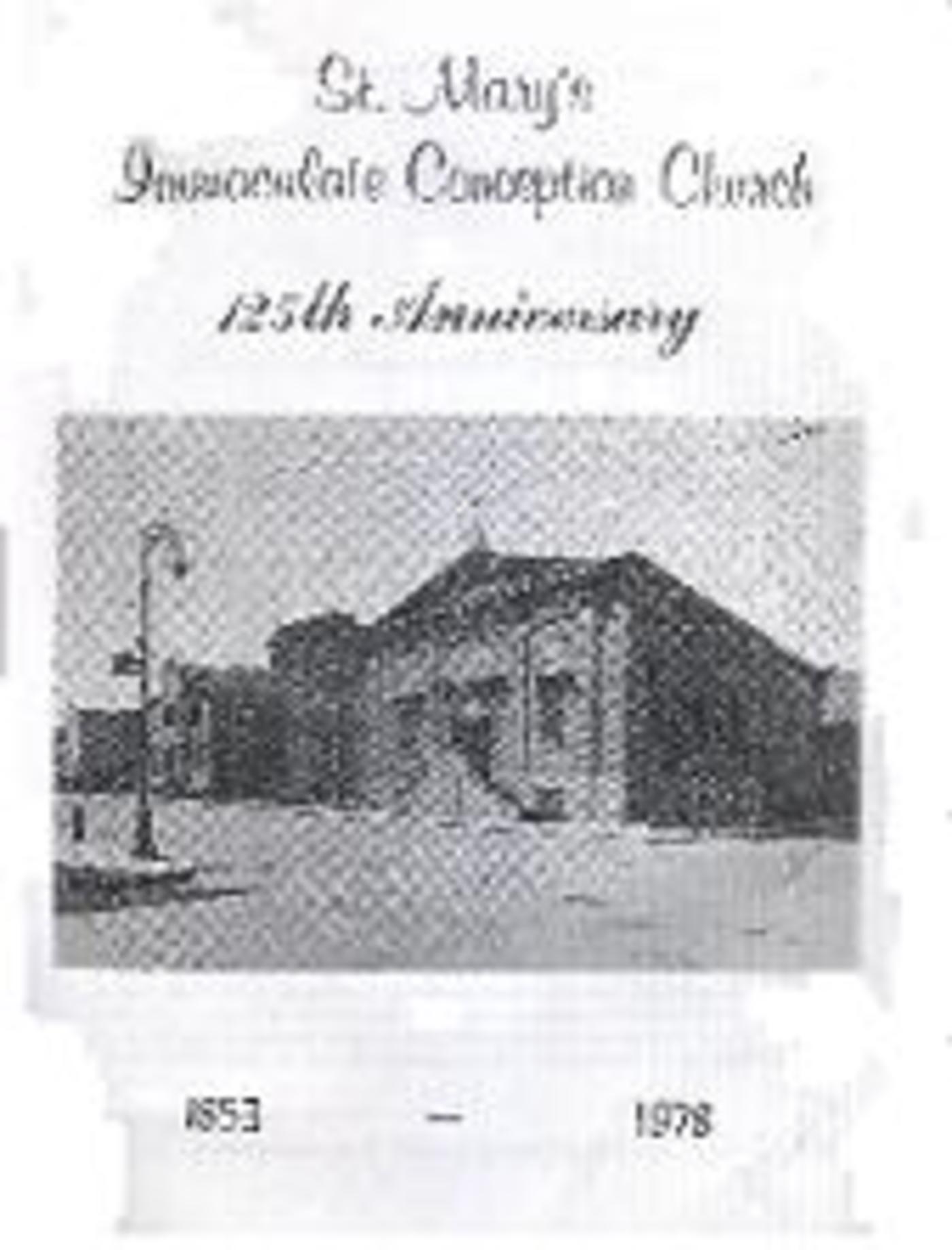
History of Williamsburg first printed in the booklet from St. Mary's Immaculate Conception Church, 125th Anniversary. (May, 1978): 9-14.
BEFORE THE IMMIGRANTS CAME
Before pursuing the story of the parish [of St. Mary's] growth, a glance at the earlier history of the area would provide an instructive context within which to review that growth. Brooklyn originally consisted of six towns of which Flatlands was the first settled in 1624 by the Dutch. In the following year, Flatbush began to be settled; then Brooklyn (Dutch Breuckelen - “Broken Land”) in 1636. In 1638 Bushwick saw its first farming families. The vast Bushwick acreage included present-day Williamsburg and Greenpoint. Dutch family names are commemorated in many local street names: Meserole, Calyer, Skillman, Devoe, Powers, Scholes, Remsen, Conselyea, McKibbin and Nichols. Even in the early days the rich ethnic mix of the area is attested to by many family names from Scandanavia, Iceland, Flanders, France, Italy (A Cesare Family), Portugal, Spain, England, Scotland and Ireland. Indians and half-breeds were also settled and some Negroes. The New Utrecht, another Dutch settlement, began in 1642, and Gravesend (Coney Island), the only English Settlement in 1643.
It was the Dutch West India Company that administered the affairs of the Dutch colony, called “New Amsterdam”, first explored by Henry Hudson in 1609. Basically fur traders, the company also purchased land for farming settlers. It was thus on August 1, 1638 that the whole area which they called “Boswick” (“Place of the Deep Woods”) was purchased from the Indians for 8 fathoms of duffels, 8 fathoms of wampum, 12 kettles, 8 adzs, 8 axes, some knives, beads and awl blades. In 1660 the first hamlet was laid out, centering on present day Woodpoint Road and Conselyea Street. A Dutch Reformed Church was erected at what in now North 2nd and Humboldt Street. It was at that time (March 14, 1661) that Governor Peter Stuyvesant gave the tiny village its name. Heavy forests were cleared for farming. The area grew slowly. A second village grew around Flushing and Bushwick Avenue, and a third, the nucleus of Williamsburg, between Bushwick Creek and South 4th Street.
Shortly after the American Revolution, Williamsburg became a focal point of intense activity by land developers. In 1892 Richard M. Woodhull, a New York City merchant, bought considerable tracts of land, hoping to attract settlers from across the river. He envisioned it as a comfortable residential suburb. He hired Colonel Jonathan Williams, a grand nephew of Benjamin Franklin, to survey the land and lay out city lots for homes. So impressed was Woodhull with the survey, that he named the area “Williamsburgh” after the surveyor. The “H” in the name was dropped years later. Woodhull provided a small ferry from Grand Street in New York City to North 2nd Street in Williamsburgh. Access to the ferry on either side of the river was very poor, however, so the proposed development came to grief and Woodhull went bankrupt.
The shrewd Stuyvesant had selected the Bushwick site on an Indian road that faced his farm across the river in lower Manhattan. Bushwick was thus a first line of defense for his farm against Indian attacks. The Dutch Farms were laid out in long, narrow strips, so that each farmer would have immediate access to water and transport of his produce. The early settlers used a “Kiekow” (lookout), a small tongue of land jetting out from the foot of North 4th Street as a place to watch for Indians. A Blockhouse was erected on this bluff and used as a place of worship and also as a refuge against Indian attacks. Jan (or Jean) Mesrol was the original owner of the river farm on which the “lookout” Stood. He had come with his wife and child in 1663 from Picardy on the speedy ship, “The Spotted Cow”. Early settlers like the Meseroles (a variant spelling) had to suffer not only from Indians, but from floods and famine as well. English colonists from Connecticut and eastern Long Island often mounted raids on the Dutch, seeking to extend British crown territory. The English did finally capture all of “New Amsterdam” in 1664. The Dutch regained their colony for a brief period but lost it again in 1674. The peace treaty gave them Surinam in exchange for New Amsterdam. The English would in turn lose “New York” (the new name they gave the colony) in the American Revolution a hundred years later. The part of Bushwick that became Williamsburg was called by the Dutch “Bushwick Shore” or simply “The Strand.”
The Woodhull bankruptcy in 1811 saw his ferry line pass by a sheriff’s sale of his assets to the Roosevelt family, Woodhull had purchased his 15 acres from a Charles Titus. A new realtor now appeared on the scene in the person of Thomas Morrell from Newtown. The Titus homestead became the “Fountain Inn” a focal point of local political discussion. Morrell purchased another 28 acres from Folkert Titus, extending from North 2nd Street to South 1st Street along the river. He gave the development a new name “Yorktown” (after the Virginia city where General Cornwallis had surrendered to General Washington to end the Revolutionary War). He built another ferry. Like Woodhull, however, Morrell also experienced failure, because the farmers would not permit passage to the ferry through their farms along the shore. The lack of direct roads made it necessary for farmers from Wallabout and other areas to take long and roundabout routes to get to “Yorktown”. It is hard for us to picture the difficulty in our day. In those times roads were few large tracts of woodlands made wagon traffic impossible in many areas. Ready access to water was essential to reach the Manhattan market, ill very much the center of activities.
POLITICAL GROWTH
These frustrations to progress were eventually dealt with, as political strength gradually emerged and the original six hamlets grew closer together and finally merged into the one city of Brooklyn in 1855. In 1827 the village of Williamsburgh was incorporated. Since the name “Williamsburgh” antedated “Yorktown”, that name generally came to be the popular designation for the Woodhull and Morrell Development. The establishment of a large distillery in 1819 (later the site of the Schaefer brewery) gave the first real impetus to local growth. Noah Waterbury established this plant at the foot of South 2nd Street. He was born in 1789 at Croton, Connecticut, came to Brooklyn in 1807 and to Williamsburgh in 1819. Seven hundred fifty nine (759) people lived here then. So important was the distillery to the area that he was called the “Father of Williamsburgh.” Docks, warehouses, rope- walks (long rectangular factories where rope was spun by hand), shipyards, iron foundries, hat factories and the largest glue factory in the nation soon dotted the community. The forest soon disappeared, and so did the famous Ailanthus tree, imported from China in the 1840’s; that tree flourished in the swampy, low-lying areas of Williamsburgh and was popular because of its supposed powers to dispel diseases arising from swamp vapors. This tree gave the title to Betty Smith’s novel about Williamsburg “A Tree Grows In Brooklyn.”ln 1835, the first local newspaper appeared: “The Williamsburgh Gazette.” In that same year, nine trustees were elected to govern the village. The commercial enterprises guaranteed success for the realtors who began building homes to accommodate them. The growth, though, became intense only when the Williamsburgh Bridge was opened in 1903. Up to that time the area boasted many impressive and fashionable hotels and elegant brownstones. Owners of the new businesses lived there and enjoyed splendid vistas of the New York harbor.
In 1843 Williamsburgh became a “town” distinct from Bushwick. That year saw a period of financial collapse, due to the inflation resulting from wild real estate speculation. Confidence was restored in 1845 when newer ferries were built to guarantee transport. By then the population had grown from 759 (18 19) to 934 (1820) to 11,000 people, enough to warrant the establishment of a bank in 1851 by Samuel Meeker in the basement of the “Universal Church” at Bedford and South 3rd Street In that same year Willamsburgh became an incorporated city Meeker drew up the city charter. In 1854 Bushwick and Williamsburgh were consolidated to form the “Eastern District”. In 1855 these became part of the City of Brooklyn and it was from this time that Williamsburgh was spelled Williamsburg. In 1889 the Greater City of New York was formed, consisting of the present five boroughs.
ON THE STREET WHERE YOU LIVE
Almost all the streets within the present parish boundaries [of St. Mary’s] are now name streets and all of them give some clue to its historic past. Originally, though, most had just numbers. It is surprising that the names of Woodhull and Morrell, the realtors who first had official surveys made for street locations, are not remembered by a single street sign commemorating their contributions to the area. Nor is there a street named for any member of the Titus family, wealthy Dutch farmers in the early period. Most of the streets were not actually immediately laid out from those early surveyors maps drawn up in the period 1792-1835. Grand Street was one that was actually laid out, however, and named after the Grand Street in Manhattan, where the first ferry terminated, allowing farmers to bring produce there. From 1835 through the 1850, the surveyors’ plans were carried out by city engineers who laid out the streets, initially only dirt roads, which were later gradually paved.
Maujer Street was originally called Remsen Street, after Abraham Remsen, a farmer whose property began at what is now the junction of Maujer and Union Avenue. The lower portion was once also called Manhattan Street. On 1835 maps, it went from South 1st Street to Bushwick Avenue. In 1869 it was extended to Morgan Avenue. On April 30, 1937 the name was changed to Maujer Street for Daniel Maujer, Esq., and alderman in the old 15th Ward. He owned land at the junction of Remsen and Union. The change was made to avoid confusion with the downtown Brooklyn’s Remsen Street. The old Union Cemetery once occupied the area bounded by Maujer, Stagg, Leonard and Lorimer Streets.
Bushwick Avenue (Eastern Parish Boundary) in the oldest street in all of Bushwick, dating back to the earliest Dutch occupation. Peter Stuyvesant named it on March 14, 1661. The name is generally said to mean “Place Of the Woods”. The area was dense with forests, thickets, scrub oaks, logs and low land. British soldiers used a great deal of the wood for fuel.
Rodney Street dates from 1835 and honors Cesar Rodney, a general in the Revolutionary War and a signer of the Declaration of Independence.
Keap Street, like Rodney, is on 1835 maps. The land for both streets was formally deeded to the city in 1858. It was actually named for another signer of the Declaration, Thomas McKean; the name was erroneously transcribed as “Keap” and never corrected.
Hooper Street (maps 1835, land deeded 1852) is named for William Hooper, signer of the Declaration of Independence.
Hewes Street, originally a farm lane (1810) on General Jeremiah Johnson’s farm, was named in 1835 for Joseph Hewes, a signer of the Declaration of Independence. He also headed the naval committee for the 13 colonies.
Union Avenue in 1835 went from Withers Street to South 6th Street. The first sections were opened on September 8, 1861. It was so named because in 1835 it “united” Williamsburgh and Bushwick, which until then had been separate villages.
Lorimer Street recalls the middle name of John and James Graham (after whom Graham Avenue is named), two famous land-jobbers, active in 1836 selling building lots in the area. The street was originally called Gwinette Street, after Button Gwinett, a signer of the Declaration of Independence. In 1835 it extended from South 6th Street to Greenpoint and was extended north to Noble Street in 1868. The name was changed on April 23, 1901.
Leonard Street (formerly the name in 1835 of present-day Lorraine Street in Red Hook) is one of the more recent streets in the area. It was opened from Broadway to Greenpoint Avenue on October 4, 1852.
Manhattan Avenue (“manah”, island and “atin”, hill) has, since May 24, 1897 been the name of the street originally called Ewen Street (1835). Daniel Ewen was a surveyor of the old and new village of Williamsburg. Ewen Street stretched from North 6th Street to Greenpoint line. The section from Greenpoint Avenue to Newtown Creek was formerly Union Avenue, and a section between South 5th Street and Java Street was once called Hill Road, and another; piece “Union Place” and in 1867 another stretch was called Orchard Street: It was called Manhattan after the borough across the river.
Graham Avenue was named in 1835 for John and James Lorimer Graham, very successful agents for local realtors selling building lots. In those days such agents were called “land-jobbers.”
Humboldt Street (originally 1835 Wyckoff Avenue and later, Smith Street and Smith Avenue) was paved and opened in 1851 from Flushing Avenue to Greenpoint Line. It was renamed somewhere between 1869-1890 to honor Alexander Humboldt (1769-1859), the German explorer of the Orinoco and Amazon rivers (in 1799-1804) and the founder of geophysics.
The Parish Streets running East-West are shorter and will generally be of later date than the North-South streets, though not in every case. Our survey begins with the southernmost and works north.
Debovoise Street commemorated Charles Debevoise, a villager who lived on Flushing Avenue. Opened in 1852, it was earlier known as Banzett Street. Debevoise was a descendant of Carl De Devoise (the name means “Beautiful Road”), the first schoolmaster in the area.
Cook Street recalls an old resident family whose farm home was located at the “crossroads” of Flushing and Bushwick Avenue”
Varet Street opened in 1883, is named for Lewis I. Varette, a land speculator in the area.
Moore Street recalls Thomas C. Moore, who owned land in the area, a manufacturer of wire sieves and netting was opened in 1852.
Siegel Street (once called Marshall Street) in named for Major General Franz Siegel (1824-1902) of the Civil War Union Army. The street was opened in 1852 from Broadway to Bushwick. Siegel had been born in Germany, came to this country and played an important role in engaging the sympathies of German immigrants to the Union cause. His military skill helped save St. Louis from the Confederates. He was later a customs agent and an editor of the “New York Monthly”. A commemorative statue was erected in 1901 on Riverside Drive in New York City.
McKibbin Street was opened in 1853 from Broadway to Bushwick. Part of the Jacob Boerum farm, it was purchased by John McKibbin and a certain Nichols (his partner). They built homes for German settlers. The area was therefore called “Dutchtown.”
Montrose Avenue was opened in 1850 in what was by then already known as the “German Quarter” (as the section bounded by Bushwick, Metropolitan, Meeker and Union Avenues was called “Irish Town”) Originally opened from Union to Bushwick Avenue, Montrose was extended in 1906. The origin of the name is not known.
Meserole Street (spelled originally Messerole) was laid out in 1835 through Abraham Messerole’s farm, from Union Avenue to Bushwick Avenue. In 1948 it was extended to Seneca Avenue.
Scholes Street (1835) recalls the family of James Scholes, land owners in the area. He purchased the Jeremiah Remson farm in 1831. Paved in 1850, it was extended from Bushwick Avenue to the county line in 1904.
Stagg Street: The origin of the name is not clear. Possibly it honors Peter Stagg, one of the commissioners who laid out the streets in 1835. Opened in 1853, it extended from Union Avenue to Bushwick Avenue and was extended, along with Scholes, in 1904 to the borough line.
Ten Eyck Street, formerly Wyckoff Street, was opened in 1852. In 1904 it stretched from Union Avenue to Newtown Creek. It recalls Richard Ten Eyck, one of the 44 men whose wealth in 1847 was estimated to exceed $10,000, a very large sum in those days.
Maujer Street (formerly Remsen) has already been described. When the name was changed, Daniel Maujer represented the area’s 15th Ward as Alderman.
Grand Street dates from 1835, and like its Manhattan counterpart, suggests the “grandeur” of the many shops lining either side of the street. The Lower section had been called Washington and then Dunham street. As early as 1812 a section ran thru the Morreil farm. In 1836 it was extended thru the Conselyea farm and in 1855 from Bushwick Avenue to Metropolitan.
Powers Street (1835) is named after William E. Powers, a zealous clerk in the realty office of the Graham Brothers (after whom Graham avenue was named). Powers was designated the nominal proprietor of vast acres for convenience in arranging sales
Ainslie Street (1835) honors Justice James Ainslie, a member of the Board of Trustees (1828-36) of Williamsburg. It was officially opened and paved in 1850 along with Devoe.
Devoe Street (1835) recalls the Devoe family of old Bushwick Village. It was formerly opened in 1850. The Devoe family owned the land near south side of North 2nd, but lived in Bushwick. (The street if not named after the Frederick Devoe family, which did have a farm along the East River shore).
The Number Streets (South 5th to North 3rd). When Richard Woodhull had the area surveyed in 1792 (he had purchased 12 acres), he simply gave the streets numbers, except for Grand Street and a lane along the waterfront which he called “Water Street” and another East River street called “River Street” (now under water). Grand Street divided the north and south numbered streets (1828). North 2nd Street was once part of the old Jamaica Turnpike. In Woodhull’s time the north-numbered streets stopped on North 12th. The south streets (from 1836) extended to South 11th Street, just at the line dividing Brooklyn from Williamsburg. These numbered streets therefore count as among the very oldest in the parish [of St. Mary's]. The north-south named streets were similarly originally designated with numbers 1st, 2nd. etc. In 1885 the north-south numbered streets were given names. (First Street is now Kent, Second Street is now Wythe, and so on).
Metropolitan Avenue was originally called Bushwick Street, Later Woodhull Street and then North 2nd. Eventually combined with the Jamaica Turnpike and Williamsburg Turnpike it became Metropolitan Avenue.
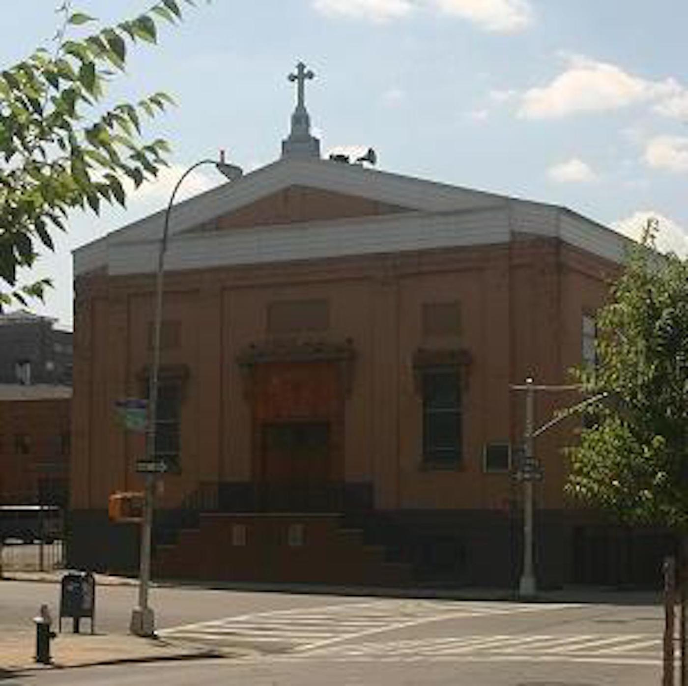
St. Mary's Church, formerly located at the corner of Leonard and Maujer Streets (five blocks away from Most Holy Trinity Church), was a good neighbor to Most Holy Trinity for more than one hundred and fifty years. This photo was taken in September of 2005. The two parishes merged under the name "Most Holy Trinity--St. Mary" in September of 2007.
“St. Mary’s Maujer Street,” as the parish was called until it merged with Most Holy Trinity in September of 2007, was Trinity's closest neighboring Catholic church (just five blocks from door to door). Saint Mary's was located at 72 Maujer Street, Brooklyn, New York 11206 and the last pastor was Rev. Alex G. Abugel
A special thank you to Friar Timothy Dore, OFM Conv. for researching and providing the parish history and information for the website.